


A building plot for sale in Niechorze (Rewal commune, Gryfice district) located in a prestigious area near the lighthouse in the second building line, in the vicinity of an increasing number of guest houses and recreation centers. Silence, birdsong… All utilities are located on the road adjacent to the plot. The plot is covered by the Local Spatial Development Plan (ZZP) and includes single-family housing and tourist services (MN/UT, details in the text).
Access to the plot is via a municipal asphalt road.
The nearest descent to a quiet beach is 800m.
The lighthouse with many accompanying attractions is only 1 km away.
Rewal , one of the most attractive tourist seaside towns, is just 2 km away (25 minutes by walk, 5 by car…), as is the Pier in Niechorze.
A major advantage of this location is its proximity to the new narrow-gauge railway station , which connects Trzęsacz, Rewal, Śliwin, Niechorze, and Pogorzelica. It’s definitely the most attractive way to explore this part of the coast!
PARAMETERS
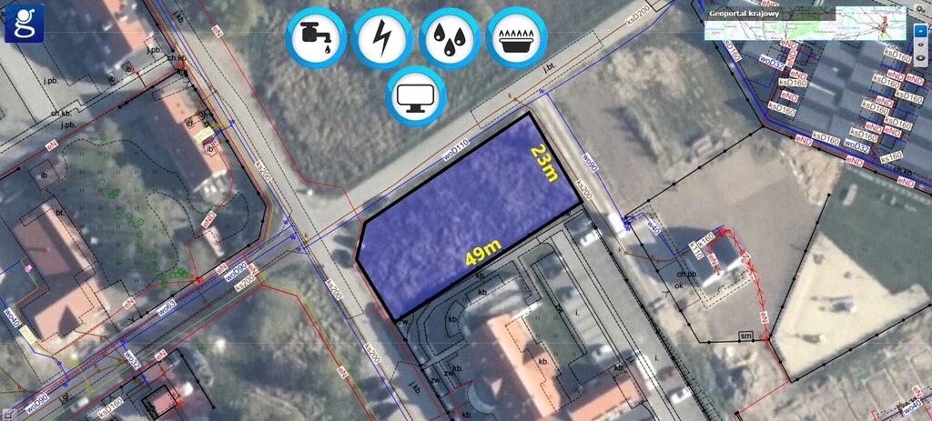
Area: 1059m
Dimensions: 23m x 49m
Plot shape: rectangle
Slope : perfectly flat
Fence: on 1 side
Appearance: grass and a few small trees that can be cut down as needed
Soil class: R3b
Soil: dry
MPZP: YES – single-family housing and tourist services (MN/UT).
2. In the areas referred to in paragraph 1, the following locations are permitted:
1) farm buildings and garages; 2) construction equipment; 3) sports and recreational equipment; 4) technical infrastructure networks and equipment; 5) pedestrian or bicycle routes, access roads and walkways; 6) parking lots and parking spaces; 7) field structures related to the provision of facilities and retaining walls; 8) greenery.
3. With respect to the principles of development and area development indicators referred to in par. 1, the following are established: 1) impassable building lines, in accordance with the plan drawing; 2) in accordance with the building lines on the plan drawing, development is permitted: a) in areas 31MN/UT and 32MN/UT on the border with the road marked as 14KDD, only from the second floor, so as to maintain passage and travel on the road marked as 14KDD, b) in areas 32MN/UT and 33MN/UT on the border with the road marked as 17KDD or the public pedestrian and vehicle route 14KDX, only from the second floor, so as to maintain passage and travel on the road marked as 17KDD and the public pedestrian and vehicle route marked as 14KDX; 3) development intensity: a) minimum – 0.0, b) maximum – 1.2.
4. Building area – maximum 25% of the building plot area.
5. Biologically active area – minimum 40% of the building plot area.
6. Arrangement of the mandatory greenery management area in the area of 32MN/UT, in accordance with the plan drawing.
7. Maximum building height: a) for residential, residential-commercial and service buildings: – in the case of buildings with flat roofs – 9 m, – in the case of buildings with gable and multi-pitched roofs – 12 m, b) for farm buildings, garages, sheds and gazebos – 8 m.
8. The foundation level of the ground floor floors should not be higher than 0.7 m above the existing ground.
9. Roofs: a) symmetrical, gable or multi-pitched roof, with an angle of inclination of the main surfaces from 25º to 45º, b) flat roof.
POSITION
Distance to existing buildings: 20m
Neighborhood: undeveloped areas, forest, meadows
Access road: asphalt
Access to public road: direct
MEDIA
– gas: on the main road next to the plot (GS25)
– electricity: WZ box on the plot
– water: on the main road next to the plot (water 110)
– sewerage: on the main road next to the plot (ks200)
– optical fiber: on the municipal road 150m away
Interested in a no-obligation meeting? Call us today!
We speak English, so please don’t hesitate and contact us for more details.